Where is Garmsar?
Area
Garmsar is one of the counties in Semnan province with an area of about 5,182 square kilometers. It is located in the westernmost part of the province and is the closest county to Tehran province. The Garmsar plain extends from east to west (48 kilometers) and from north to south (27 kilometers). Additionally, this county is situated next to the Silk Road (Imam Reza Road) and the junction of the North National Railway (Gorgan).
The county of Garmsar is approximately 95 kilometers away from Tehran province and 110 kilometers away from the center of Semnan province.
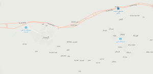
Neighbors of Garmsar County
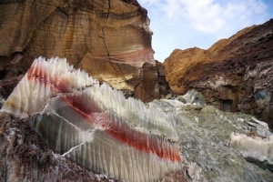
Garmsar County is bordered by Firuzkuh and Damavand to the north, Sorkhe and Aradan to the east, Pakdasht and Qom Province to the west, and Aran and Bidgol to the south. It is worth mentioning that the areas around Garmsar are drained by the HablehRod River, which originates from the central parts of the Alborz mountain range. The surroundings of Garmsar, except for the southern parts that lead to the desert, are surrounded by the Siahkooh mountain range. Garmsar County is well-known as the "Salt Capital" of Iran due to the presence of various salt mines.
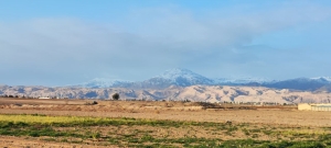
A beautiful view from inside the village of Malekabad in Garmsar county.
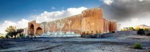
An image of the exterior view of Shah Abbasi Caravanserai.
The population of Garmsar
Based on the latest census conducted in 1385 (solar calendar), Garmsar County had a population of 39,523, which undoubtedly has increased over the past years.
The majority of the population in Garmsar speaks Persian. However, in other areas of Garmsar, such as the center and villages of the Ivanaki district, which is also bordering Tehran province, the Tat ethnic group resides and speaks the Tat language. Additionally, Azerbaijani-speaking ethnic groups (such as Osanlu and Pazuki) have settled in Garmsar since ancient times. Furthermore, ethnic groups like Ilykayi, Shahmirzadi, Mazandaranis, Arabic speakers, Gilaks in the Qalibaf region, Kurdish Shamlou, Qarachorlu, and Lurs of Dinarvand also inhabit this city, making it an attractive and diverse place of residence.
The history and chronicles of Garmsar
This beautiful, remarkable city was known as "Khar" in the past. In the year 1319 (Solar Hijri calendar), the name of this city was changed to its current name. Additionally, in ancient times, it was also called "Qashlaq," and during that period, the city consisted of four blocks: Qashlaq, Yatari, Aradan, and Rikan.
In the past, this county was part of Tehran Province, and over time, with the implementation of new national administrative divisions, this part has been considered part of Semnan Province. also Currently, it is divided into three districts: Central, Ivanaki, and Aradan.
It is worth mentioning that this city is one of The Sixteen AvestaLands with the name (Vern) also, It was called "Khara" during the Assyrians period.
In the past, this county was part of the regions of Rey or (Raga). And during the Seleucid and Arsacid periods, due to the existence of strategic regions, it has been of great importance. For example:
- The presence of the Caspian Gate or the Khazar Gate, which had an iron gate and guards, and its purpose was to separate the border between the Medes and the Parthians.
- During the Seleucid era, important city structures, including KharaX, were built in this ancient city.
- Placing beside the Silk Road a network of interconnected roads with the aim of facilitating trade in Asia, connecting East and West and South of Asia, and linking North Africa to Eastern Europe, and...
Most of the historical monuments in this city are in the form of ruins of large castles and fortresses, of which only large mounds remain today due to erosion and the passage of time. These ancient fortresses, during the Achaemenid, Parthian, and Seleucid periods, constituted major cities. Among the well-known and remarkable historical mounds and fortresses in Garmsar, we can mention mounds such as Ghoul Abad, Dezmaran, Saadabad, Jeiran Tepe, and fortresses such as Deh Namak Castle and Kahak Castle, Bahram PalaceRikan Castle, Panj Tan Castle, Rashmeh Castle, Ivanki Castle, Sardar Castle, and Padah Castle.
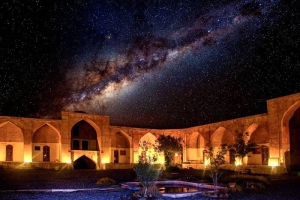
Shah Abbasi Caravansearai in Aradan
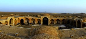
Exterior view of Ghasr Bahram Caravanserai
Weather
The elevation of this city above sea level is 856 meters. A significant part of Garmsar has a dry and desert climate, or in other words, it experiences hot and dry summers and cold and dry winters.
Souvenirs
Some of the prominent souvenirs of this city include top-quality and exportable melons and summer crops, pomegranates and pomegranate paste, as well as pure dairy products (related to the Ilikaei and Sangsari tribes, who were nomadic in the past). Handicrafts in this region, such as khorjin weaving, pottery, carpet weaving, jajim weaving, fabric weaving, wood carving, and marquetry, have gained significant popularity among enthusiasts in the global markets.
Some popular and well-known local foods and edibles in Garmsar include: Tah Chin( A type of Garmsar cuisine) potted meat, Gur Maast, Local Taftan bread, Local fatir bread, kake bread, pan chapati(Barley flour bread), Agerdak, kelva , Jezzak bread (Bread made from the remaining sheep fat, which, after heating, its oil is extracted, and it takes on a crispy texture)
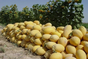
summer crops ,are one of the souvenirs of Garmsar

Barley bread (chapati made from barley flour)
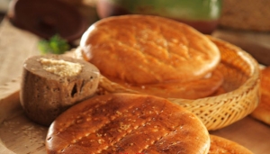
Fatir bread

kelva

Local Taftan Bread of Garmsar

Agerdak bread
Tourist Attractions in Garmsar
Some of the tourist attractions and areas in this city include:
Rig Jen Desert (that is known as the Bermuda of Iran), Kavir National Park (a protected area and the habitat of the Iranian Cheetah and Persian Goitered Gazelle), Ghoolabad Hill, Dezmaran Hill, Saadabad Hill, Jeiran Hill, and fortresses such as Deh Namak Fortress, Kahak Fortress, and the Caravanserai. Bahram PalaceRikan Castles, Panjtan Castle, Rashme Castle, Ivanaki Castle, Sardar Castle, Padah Castle, Salt Mines Sardareh Stone-Paved Road Black Mountain , Historical House of Baqeris (Ethnic Museum), Zolam─üt Strait, Salt Cave, Dragon Mountain, Kalarz Peak, Historical Complex of Black Mountain, Garmsar Water Reservoir, Estonavand Castle, Naroh├® Castle, and Salt Tunnel of Garmsar
mention.

A beautiful view of salt ponds in the salt mines of Sardareh in Garmsar.
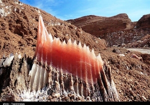
The abundance of salt mines in Garmsar.
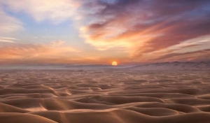
The" Rig jen" sandy desert dunes during sunset.

Garmsar Salt Cave

